Question
USING THE FOLLOWING 2 IMAGES PLEASE ANSWER QUESTIONS 26, 27, 28 AND 32! THANK YOU SO MUCH! :)
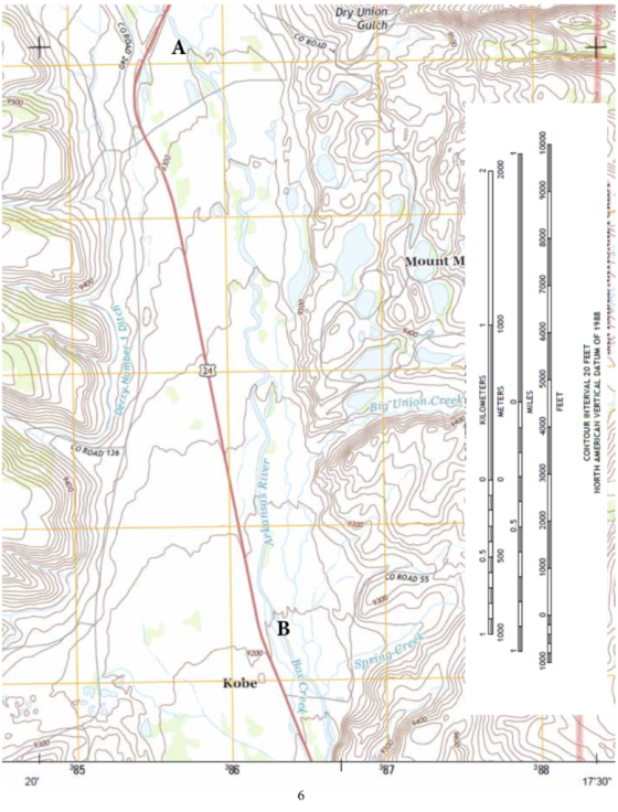
IMAGE 1 IS FOR QUESTION: 26
IMAGE 2 IS FOR QUESTIONS: 27, 28 AND 32 :)
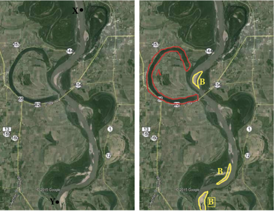
82 2015 Google 2015 Google (B
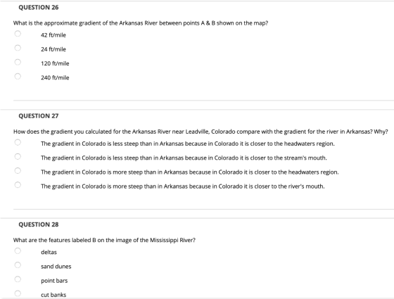
QUESTION 26 What is the approximate gradient of the Arkansas River between points A & B shown on the map? 42 ft/mile 24 ft/mile 120 ft/mile 240 ft/mile QUESTION 27 How does the gradient you calculated for the Arkansas River near Leadville, Colorado compare with the gradient for the river in Arkansas? Why? The gradient in Colorado is less steep than in Arkansas because in Colorado it is closer to the headwaters region. The gradient in Colorado is less steep than in Arkansas because in Colorado it is closer to the stream's mouth. The gradient in Colorado is more steep than in Arkansas because in Colorado it is closer to the headwaters region. The gradient in Colorado is more steep than in Arkansas because in Colorado it is closer to the river's mouth QUESTION 28 What are the features labeled B on the image of the Mississippi River? deltas sand dunes point bars cut banks
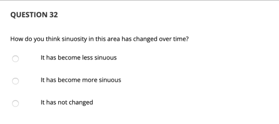
QUESTION 32 How do you think sinuosity in this area has changed over time? t has become less sinuous It has become more sinuous It has not changed
Homework Answers
Answer #1
26. The gradient is 100/2.5= 40 feet/mile
So option 1 is correct
28. The feature is a point bar.
32. The area has become less sinuous.
Know the answer?
Add Answer to:
USING THE FOLLOWING 2 IMAGES PLEASE ANSWER QUESTIONS 26, 27, 28 AND 32! THANK YOU SO MUCH! :) IMAGE 1 IS FOR QUESTION: 26 IMAGE 2 IS FOR QUESTIONS: 27, 28 AND 32 :) 0 River 0.5 KILOMETERS METERS 0....
Not the answer you're looking for?
Ask your own homework help question.
Our experts will answer your question WITHIN MINUTES for Free.
Similar Homework Help Questions
ADVERTISEMENT
Need Online Homework Help?
Ask
a QuestionGet Answers For Free
Most questions answered within 3 hours.
Most questions answered within 3 hours.
ADVERTISEMENT
ADVERTISEMENT
Active Questions
-
4. Without doing any calculations, predict whether the observed
∆T would increase, decrease or remain the...
asked 1 hour ago -
Based on the range, which of the following sets of scores has
the greatest variability? 3,...
asked 2 hours ago -
Ripples in a pond travel at a velocity of 3 m/s with one peak
passing a...
asked 2 hours ago -
A man stands on the roof of a building of height 13.0 mm and
throws a...
asked 2 hours ago -
The extent to which assets are financed by borrowed funds and
other liabilities is indicated by:...
asked 3 hours ago -
Explain in detail
Germany is the fifth largest economy
explain what goods and services Germany specializes...
asked 3 hours ago -
The density of platinum is 21.45 g/mL. If a cube of platinum
with a mass of...
asked 3 hours ago -
Accounts Receivable
Sales
A/R Posting
Extended Sales Invoice
Packing Slip
Compare invoice to packing slip 2...
asked 3 hours ago -
Michaella, age 23, is a full-time law student and is claimed by
her parents as a...
asked 3 hours ago -
Why are polymers not typically casted into products?
asked 3 hours ago -
When rolling a die 129 times, what is the probability of rolling
a 6 no more...
asked 4 hours ago -
4. A call option currently sells for $7.75. It has a strike
price of $85 and...
asked 3 hours ago
ADVERTISEMENT