
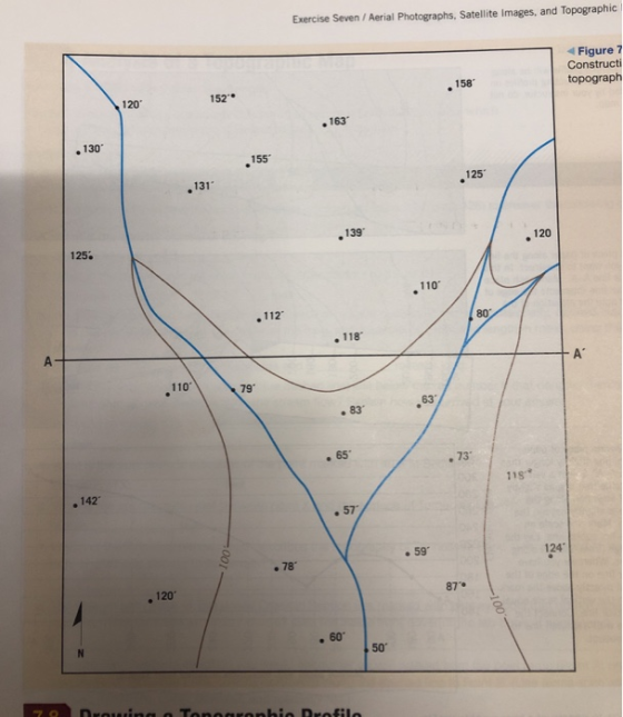
Exercise Seven / Aerial Photographs, Satellite Images, and Topographic 1 Figure 7 Constructi 158 152 120 163 130 155 131 125 139 125. 120 110 112 80 118 110 79 63 83 65 .73 1S .142 ,57 59 124 78 120 87° 60 50
Homework Answers
Ans.
Before answer the question, we must know that the contour lines are the lines joining the points of equal elevation. Here also I will try to map the point with same elevation.

Here I have taken the contour interval of 20 feet which is written with brown color.
Ans. 2
Yes the land is sloping from north to south (towards south) as we can see from the map above.
Ans. 3
In the below figure, the arrows show the direction of stream that follows the pattern of slope of the topography and it is to some extent, a dendritic pattern.

I hope the answer is clear to you now, If you have any further query, please leave a comment, I will try my best to solve it for you. Goodluck
Add Answer to:
Constructing a Topographic Map 7.7 Construct a simple topographic map by drawing contour lines. Early topographic...
please can you draw me this exercise of topography Locate the lowest closed concentric contours and...
 please can you draw me this exercise of topography
Locate the lowest closed concentric contours and writethe label iu "depression." Be sure to add tick marks on the do label depression contours Locate the highest closed concentric contours and write i rs and write in the Step 4: Once you've completed this practice exercise, check your answer with the in the back of this lab manual or in the online supplement. Once you're results, you are ready to complete the...
please can you draw me this exercise of topography
Locate the lowest closed concentric contours and writethe label iu "depression." Be sure to add tick marks on the do label depression contours Locate the highest closed concentric contours and write i rs and write in the Step 4: Once you've completed this practice exercise, check your answer with the in the back of this lab manual or in the online supplement. Once you're results, you are ready to complete the...
Most questions answered within 3 hours.
-
I need to write a research paper and work cited about this
topic: The United States...
asked 8 minutes ago -
Hello! I was wondering if I could have some help?
If the vapor pressure of carvone...
asked 30 minutes ago -
An economist wants to estimate the mean per capita income (in
thousands of dollars) for a...
asked 50 minutes ago -
What would be the input/output characteristic of a circuit
obtained by putting two of your 2's-complementers...
asked 49 minutes ago -
In Drosophila, the transition from the syncytial blastoderm
stage to the cellular blastoderm stage is a...
asked 1 hour ago -
Project management question:
Name 3 different types of resources (hint: humans are one
type)
asked 1 hour ago -
Consider the following reaction: C 2H 2( g) + 2H 2( g) C 2H 6(
g)...
asked 1 hour ago -
Consider a 1.0 L buffer containing 0.092 mol L-1 HCOOH and 0.100
mol L-1 HCOO-. What...
asked 1 hour ago -
Koch Realty has owned a vacant land with a FMV of
$775,000 and an adjusted basis...
asked 1 hour ago -
It is estimated 29% of all adults in United States invest in
stocks and that 85%...
asked 1 hour ago -
What does a 2-sided p value of 0.04 mean? (I am not asking if it
is...
asked 2 hours ago -
A parallel-plate capacitor is made from two aluminum-foil
sheets, each 7.8 cmcm wide and 5.1 mmlong....
asked 2 hours ago