
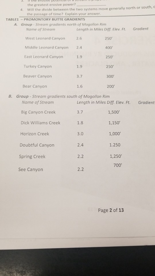
the greatest erosive power? Will the divide between the two systems move generally north or sou the passage of time? Explain your answer th, c 4. TABLE1-PROMONTORY BUTTE GRADIENTS A. Group- Stream gradients north of Mogollon Rim Gradient Name of Stream West Leonard Canyon Middle Leonard Canyon East Leonard Canyon Turkey Canyon Beaver Canyon Bear Canyon Length in Miles Diff. Elev. Ft. 2.6 2.4 1.9 1.9 3.7 1.6 250 400 250 250 300 200 B. Group - Stream gradients south of Mogollon Rim Name of Stream Big Canyon Creek Dick Williams Creek Horizon Creek Doubtful Canyon Spring Creek See Canyon Length in Miles Diff. Elev. Ft. 3.7 1.8 3.0 2.4 2.2 Gradient 1,500 1,150' 1,000 1.250 1,250 700 2.2 Page 2 of 13
Homework Answers
a. If the quadrangle map was provided, the marking the drainage divide with red pencil could be done !
b. In general, DAMs are the human made features , which are roughly coincident with the divide.
c. 1) Calculation of stream gradient (in feet/mile):
Group A :
- West leonard canyon = 250/2.6 = 96.1538
- Middle leonard canyon = 400/2.4 = 166.6667
- East leonard canyon = 250/1.9 = 131.5789
- Turkey canyon = 250/1.9 = 131.5789
- Beaver canyon = 300/3.7 = 81.0811
- Bear canyon = 200/1.6 = 125
Group B :
- Big canyon creek = 1500/3.7 = 405.4054
- Dik williams creek = 1150/1.8 = 638.8889
- Horizon creek = 1000/3 = 333.3333
- Doubtful canyon = 1250/2.4 = 520.8333
- Spring creek = 1250/2.2 = 568.1818
- See canyon = 700/2.2 = 318.1818
2) Average gradient of streams north of Mogollon Rim (Group A streams) = (96.1538 + 166.6667 + 131.5789 + 131.5789 + 81.0811 + 125)/ 6 = 732.0594/6 = 122.0099 feet/mile.
Average gradient of streams south of Mogollon Rim (Group B streams) = (405.4054 + 638.8889 + 333.3333 + 520.8333 + 568.1818 + 318.1818)/6 = 2784.8245/6 = 464.1374 feet/mile.
3) As the erosive potential of the stream is proportional to its gradient, Group B would have more erosive power because its avg. gradient is more (464.1374 feet/mile) than the avg. gradient of the Group A streams (122.0099 feet/mile).
Add Answer to:
Landforms Produced by Running Water and Groundwate Promontory Butte Quadrangle, Arizona a. Trace ...
Most questions answered within 3 hours.
-
Hello, can someone please help me answer this question?
How much heat is absorbed by a...
asked 12 minutes ago -
A business executive has the option to invest money in two
plans: Plan A guarantees that...
asked 14 minutes ago -
. A marketing researcher conducted a survey of 25 shoppers
randomly selected at the local mall...
asked 29 minutes ago -
Create an comprehensive response to the
following:
Antimicrobial agents work on a multitude of microbes (bacteria,...
asked 31 minutes ago -
6.13 LAB: Step counter. Section 6.3.
A pedometer treats walking 2,000 steps as walking 1 mile....
asked 26 minutes ago -
(14.2) A block of mass m = 10 kg riding on a frictionless
horizontal plane is...
asked 29 minutes ago -
Use any search engine to search for articles about Starbucks
partnership with Tata Companies in India...
asked 28 minutes ago -
Let’s say that for some reason Bank Excess Reserves suddenly
increase sharply. What effect would this...
asked 37 minutes ago -
Given:
Curent Assets: $600,000
Total Assets: $2,600,000
Current Liabilities: $500,000
Total Liabilities: $1,700,000
What is the...
asked 42 minutes ago -
1. What is a “Bankster”? What is insider trading? Why is it
illegal?
2. What is...
asked 40 minutes ago -
A transverse wave on a cord is given by
D(x,t)=0.18sin(2.7x−61.0t), where Dand x are in m...
asked 47 minutes ago -
ASSIGNMENT
ANSWER ANY TWO OF THE FOLLOWING IN 2-3 PARAGRAPHS OF EACH
QUESTION.
1: Where is...
asked 45 minutes ago