


Lake Wales, Florida, Quadrangle and Aerial Imagery In Florida, several sinkholes have made news because water tables lowered by groundwater Pui ven new caused their collapse into underground solution caves, taking with them homes, businesses cars from an auto dealership. One such sinkhole collapsed in a suburban area in 1981 and and 1998. The area around Lake Wales, Florida (south of Orlando and north of the Everg teristic of limestone with karst topography, high water tables, some dry depressions streams, marsh lands, and groves of citrus trees-see Figure 27.3, Topographic Map of Lake and Figure 27.5, Aerial Imagery of Lake Wales, Florida. Complete the following items relative to a in 198ndven new is charac- limited surface Wales, Florida, e dry of the 1. Refer to Figure 27.3 Topographic Map of Lake Wales, Florida. What is the scale of this map? What is the contour interval? 2. How many sinkhole depressions contain lakes in the map segment? Do any of these lakes sit in a depression (give a count) 10 ft deep? 15 ft deep? 20 ft deep? More than 25 ft deep? 3. 4. Water will flow downslope between sinkholes. Using lake- and pond-surface elevation as an indicator in which direction do you think groundwater flows through this area? Explain your thinking. Usinga dark blue colored pen, draw arrows to indicate the direction of flow of groundwater. 5. A hospital, the Lake Wales Medical Center, is shown south (SSE) of Lake Wales. Determine the eleva tion of the hospital as well as the elevation of the lake surface of Lake Wales. Hospital: If you were standing at the hospital, could you see the lake? Explain. Lake Wales:
Lab Landscap Exercise 27: : Topographic Analysis: Karst An Evaluate falling? Using a dark green colored pencil or pen, circle at least three features your statement. Describe why these three features support your assertion. e elevation of the water table over time on this map. Is the water table rising or e at least three features on the map that support 7. Do you see any evidence that the water table is at the surface or that thrpoord the region is poorly drained? Describe at least two types of features that would show a high water table or 8. What is the primary activity on the landscape? Take a look at Sections 25 and 36. Use the topographic map symbol key inside the front cover of this manual to help Identify the activity. 9. Do you find any surface streams on the topographic map? Explain your observation. What would pro- duce this hydrologic situation? canal, thueis no evid Besids the dranay oF a surfaer stream on the maup. Thure is a presence ery. in 10. List and describe three differences you can see between the topographic map and the How does each one appear differently on the map and on the aerial imagery 11. Optional Google Earth activity, Lake Wales, Florida. For the KMZ file and questions, go to mygeoscienceplace.com or the Mastering Geography Study Area. Then click on the cover of Applied Physical Geography: Geosystems in the Laboratory Mastering Geography Looking for additional lab prep and review materials? Visit the Study Area in Mastering Geography to enhance your geographic literacy and spatial reasoning skills by accessing MapMaster interactive maps, videos, Mobile Field Trips t Candor Ouadcopter Videos, In the News articles, flashcards, weh links self-study.au
CONTOUR INTERVAL 5 FEET SCALE 1:27,000 LAKE WALES, FL FLORIDA LAKE WALES T-29 SIR 2 7E 30SR28E Effie 27.3
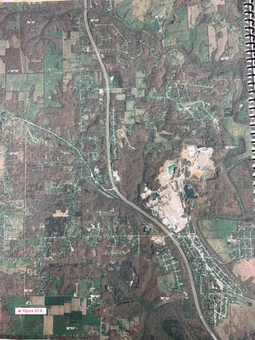
▲ Figure 274
Homework Answers
1. The scale of the map is 1:27,000.
That means 27000 unit scale on the ground equivalent to the 1 unit scale on the topographic map.
The contour interval is 5 ft given in the map.
2. There are 32 sink whole depression that contain lakes in map.
3.the lake Wales is greater than 25 ft deep as the map showing 5 contour lines of 5 ft surround the lake.
Mountain Lake is greater than 20 ft deeper.
Lake Effie is greater than 15 ft deeper.
Lake we are, Luke's, Belie is greater than 10 ft deeper.
The other ones are less then 10 ft.
Add Answer to:
Lake Wales, Florida, Quadrangle and Aerial Imagery In Florida, several sinkholes have made news b...
Question 4 8 pts This is an aerial photograph showing lakes that are characteristic of Central Florida. Answer the...
 Question 4 8 pts This is an aerial photograph showing lakes that are characteristic of Central Florida. Answer the following questions based on your observations from this photo and your understanding of groundwater and karst features. A.How would you describe the general shape of most of these lakes? B. Do you see obvious streams or canals that are draining into these lakes? C. These lakes are formed by sinkholes. Therefore: what is the most likely type of bedrock in this...
 Question 4 8 pts This is an aerial photograph showing lakes that are characteristic of Central Florida. Answer the following questions based on your observations from this photo and your understanding of groundwater and karst features. A.How would you describe the general shape of most of these lakes? B. Do you see obvious streams or canals that are draining into these lakes? C. These lakes are formed by sinkholes. Therefore: what is the most likely type of bedrock in this...
Most questions answered within 3 hours.
-
1. What is a “Bankster”? What is insider trading? Why is it
illegal?
2. What is...
asked 13 seconds ago -
Given:
Curent Assets: $600,000
Total Assets: $2,600,000
Current Liabilities: $500,000
Total Liabilities: $1,700,000
What is the...
asked 2 minutes ago -
A transverse wave on a cord is given by
D(x,t)=0.18sin(2.7x−61.0t), where Dand x are in m...
asked 6 minutes ago -
ASSIGNMENT
ANSWER ANY TWO OF THE FOLLOWING IN 2-3 PARAGRAPHS OF EACH
QUESTION.
1: Where is...
asked 5 minutes ago -
Question 1 (5 marks)
Studies have shown that the price elasticity for GP
consultations is -0.2...
asked 7 minutes ago -
The owner of 22 restaurants was asked how he does marketing
research. He answered that he...
asked 11 minutes ago -
The premium on a June 17 British pound call option with a strike
price of $1.2560...
asked 27 minutes ago -
We sometimes have to choose between the highest NPV and IRR;
will we not always get...
asked 22 minutes ago -
How do ethical issues affect decision making and what ethical
issues do you see in the...
asked 24 minutes ago -
Calculate the moment
of inertia (in kg·m2) of a skater given the following
information.
(a)
The...
asked 40 minutes ago -
A small body of mass m performs small oscillations sliding (no
rolling) along the bottom of...
asked 44 minutes ago -
The electric field in the region between two oppositely charged,
parallel, conducting plates has a magnitude...
asked 43 minutes ago