
ONLY QUESTION THAT NEED ANSWERING IS QUESTION 14 (QUESTION 2 IN THE PAGES) THANK YOU SO MUCH FOR YOUR HELP! :)
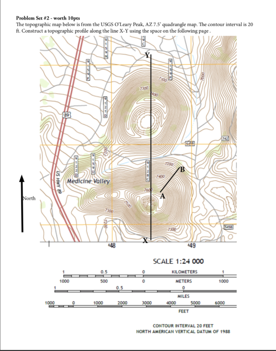
Problem Set #2 continued 1. Construct a topographic profile below along the line X-Y on the map on the previous page. You may use the index contours for the profile using the gridlines given and use the regular contours to help define the shape of the profile, especially at the summit areas. Note that at this scale, it will be difficult to accurately draw all the details -the overall shape is what I'm mostly looking for. Label the elevation of each gridline, and answer the questions below 2. Given the vertical scale of 1 in400 ft and the horizon tal scale of 1n 0.25 miles (note that the map provided is not 1:24,000 as in the original printed map), calculate the vertical exaggeration of the topographic profile. Show your wor Vertical Exaggeration- 3. The two sets of concentric closed contours on the map and the topographic profile you've constructed represent what general types of topographic features? The two sets of concentric closed contours with hachure marks on the inside represent what types of topographic features. Given the concentric closed contours without and with hachures and their relationship to each other, what type of geologic features do you think are represented in the map and in your profile? 4. In what direction is the small intermittent stream flowing where it crosses the center of the profile line? In what direction does it flow to the east of the profile line 5. What is the average gradient of the slope along the line from point A to B? Show your work.
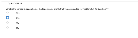
QUESTION 14 What is the vertical exaggeration of the topographic profile that you constructed for Problem Set #2 Question 1? 2.2x 3.3x 22x 33x
Homework Answers
The vertical scale is given as
1 inch = 400 feet, or 1 : 400
The horizontal scale is given as
1 inch = 0.25 miles
Since 1 mile = 5280 feet, so 0.25 miles = 1320 feet, thus the horizontal scale can be re-written as
1 inch = 1320 feet, or 1 : 1320
The vertical exaggeration is calculated as
(Vertical scale / Horizontal scale)
So the vertical exaggeration of the topographic profile is
( 1 / 400 ) / ( 1 / 1320 ) = 1320 / 400 = 3.3
Thus the correct option is 3.3x, i.e. the vertical scale is 3.3 times larger than the horizontal scale of the topographic profile.
Add Answer to:
ONLY QUESTION THAT NEED ANSWERING IS QUESTION 14 (QUESTION 2 IN THE PAGES) THANK YOU SO MUCH FOR YOUR HELP! :) Problem Set #2-worth 10pts The topographic map below is from the USGS O'Leary Peak,...
USING THE FOLLOWING 2 IMAGES PLEASE ANSWER QUESTIONS 26, 27, 28 AND 32! THANK YOU SO MUCH! :) IMAGE 1 IS FOR QUESTION: 26 IMAGE 2 IS FOR QUESTIONS: 27, 28 AND 32 :) 0 River 0.5 KILOMETERS METERS 0....
 USING THE FOLLOWING 2 IMAGES PLEASE ANSWER QUESTIONS 26, 27, 28
AND 32! THANK YOU SO MUCH! :)
IMAGE 1 IS FOR QUESTION: 26
IMAGE 2 IS FOR QUESTIONS: 27, 28 AND 32 :)
0 River 0.5 KILOMETERS METERS 0.5 MILES 1000 1000 CONTOUR INTERVAL 20 FEET NORTH AMERICAN VERTICAL DATUM OF 1988 82 2015 Google 2015 Google (B QUESTION 26 What is the approximate gradient of the Arkansas River between points A & B shown on the map? 42...
USING THE FOLLOWING 2 IMAGES PLEASE ANSWER QUESTIONS 26, 27, 28
AND 32! THANK YOU SO MUCH! :)
IMAGE 1 IS FOR QUESTION: 26
IMAGE 2 IS FOR QUESTIONS: 27, 28 AND 32 :)
0 River 0.5 KILOMETERS METERS 0.5 MILES 1000 1000 CONTOUR INTERVAL 20 FEET NORTH AMERICAN VERTICAL DATUM OF 1988 82 2015 Google 2015 Google (B QUESTION 26 What is the approximate gradient of the Arkansas River between points A & B shown on the map? 42...
Most questions answered within 3 hours.
-
The equilibrium constant for the following reaction Ag+(aq) +
2NH3(aq) Ag(NH3)2+(aq) is K = 1.7 ×...
asked 44 seconds from now -
A carbon heater element has fixed resistance of 28 Ohms. It is
connected to an A/C...
asked 13 seconds ago -
Suppose X∼Exp(λ) for some λ >0. Compute E(X) and Var(X).
asked 14 minutes ago -
Xanth Co. has 8.9% annual coupon bonds with face value of $1,000
and 7 years remaining...
asked 11 minutes ago -
The Bellevue University bookstore purchases sweatshirts with the
school name and logo from a vendor. The...
asked 14 minutes ago -
If you invest the $10,000 you receive at graduation in a mutual
fund which averages a...
asked 16 minutes ago -
Consider 15 mL of an aqueous solution containing 2.0 g of an
organic solute.If the distribution...
asked 16 minutes ago -
Define the following Marketing Psychology Principles of Human
Behavior: Priming, Reciprocity, Social Proof, Decoy Effect,
Scarcity,...
asked 32 minutes ago -
What does the graph of Range vs angle look like? Also what is
the slope of...
asked 35 minutes ago -
a
sample size of _ is needed So there a 99% confidence interval will
have a...
asked 41 minutes ago -
Strategy is an important part of project management and business
decisions. Define strategy and describe in...
asked 44 minutes ago -
Task 5.2 Numerical Analysis Using Nested Loops (13 pts)
Consider the following program:
void setup()
{...
asked 58 minutes ago